


KNYL - Yuma Mcas/Yuma Intl
Located in Yuma, United States
ICAO - NYL, IATA - YUM
Data provided by AirmateGeneral information
Coordinates: N32°39'24" W114°36'22"
Elevation is 213 feet MSL.
Magnetic variation is 13° East View others Airports in Arizona
Operational data
Special qualification required
Current time UTC:
Current local time:
Weather
METAR: KNYL 300657Z AUTO 24005KT 10SM CLR 27/08 A2980 RMK AO2 SLP089 T02720083 403720200 $
TAF: TAF KNYL 3003/3103 22006KT 9999 SKC QNH2975INS FM300700 VRB04KT 9999 SKC QNH2980INS FM301500 17005KT 9999 SKC QNH2987INS FM301800 20008KT 9999 SKC QNH2970INS AUTOMATED SENSOR METWATCH 3006 TIL 3014 T21/3013Z T38/3023Z
Communications frequencies: [VIEW]
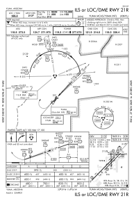
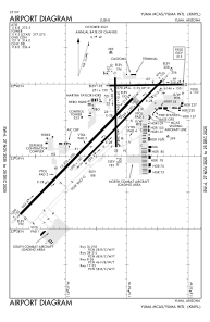
Runways:
| RWY identifier | QFU | Length (ft) | Width (ft) | Surface | LDA (ft) |
| 03L | 44° | 13300 | 200 | CONC | 13300 |
| 21R | 224° | 13300 | 200 | CONC | 13300 |
| 03R | 44° | 9240 | 150 | OTHER | 9240 |
| 21L | 224° | 9240 | 150 | OTHER | 9240 |
| 08 | 89° | 6146 | 150 | ASPH | 6146 |
| 26 | 269° | 6146 | 150 | ASPH | 6146 |
| 17 | 179° | 5710 | 150 | OTHER | 5710 |
| 35 | 359° | 5710 | 150 | OTHER | 5710 |
Airport contact information
Address: Yuma United States