


KNXP - Twentynine Palms Self
Located in Twentynine Palms, United States
ICAO - NXP, IATA -
Data provided by AirmateGeneral information
Coordinates: N34°17'46" W116°9'44"
Elevation is 2051 feet MSL.
Magnetic variation is 11° East View others Airports in California
Operational data
Special qualification required
Current time UTC:
Current local time:
Weather
METAR: KNXP 140156Z AUTO 23019G27KT 10SM CLR 30/01 A2985 RMK AO2 PK WND 24027/0155 SLP073 T03000006
TAF: TAF KNXP 1321/1421 31005KT 9999 SKC QNH2990INS BECMG 1321/1323 22010G20KT 9999 SKC QNH2983INS TEMPO 1323/1405 22015G25KT FM140530 27007KT 9999 SKC QNH2987INS T34/1323Z T19/1413Z
Communications frequencies: [VIEW]
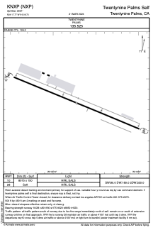
Runways:
| RWY identifier | QFU | Length (ft) | Width (ft) | Surface | LDA (ft) |
| 10 | 0° | 8015 | 150 | OTHER | |
| 28 | 0° | 8015 | 150 | OTHER |
Airport contact information
Address: Twentynine Palms United States