


KNXP - Twentynine Palms Self
Located in Twentynine Palms, United States
ICAO - NXP, IATA -
Data provided by AirmateGeneral information
Coordinates: N34°17'46" W116°9'44"
Elevation is 2051 feet MSL.
Magnetic variation is 11° East View others Airports in California
Operational data
Special qualification required
Current time UTC:
Current local time:
Weather
METAR: KNXP 170056Z AUTO 33008KT 10SM CLR 36/M01 A2980 RMK AO2 SLP052 T03611011
TAF: TAF KNXP 1621/1721 25010KT 9999 SKC 510309 511204 QNH2988INS BECMG 1706/1708 29015G25KT 9999 SKC 510309 511204 QNH2991INS BECMG 1709/17011 29005KT 9999 SKC 500000 QNH2993INS FM171800 25010KT 9999 SKC QNH2990INS T21/1712Z T34/1721Z
Communications frequencies: [VIEW]
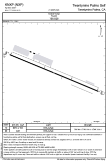
Runways:
| RWY identifier | QFU | Length (ft) | Width (ft) | Surface | LDA (ft) |
| 10 | 0° | 8015 | 150 | OTHER | |
| 28 | 0° | 8015 | 150 | OTHER |
Airport contact information
Address: Twentynine Palms United States