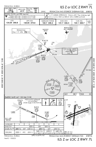
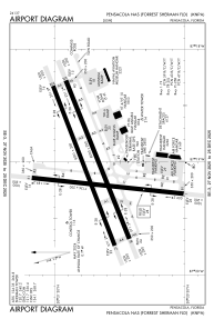


KNPA - Pensacola Nas (Forrest Sherman Fld)
Located in Pensacola, United States
ICAO - NPA, IATA -
Data provided by AirmateGeneral information
Coordinates: N30°21'12" W87°19'5"
Elevation is 28 feet MSL.
Magnetic variation is -01° East View others Airports in Florida
Operational data
Special qualification required
Current time UTC:
Current local time:
Weather
METAR: KNPA 141556Z 21014G20KT 9SM FEW022 BKN250 28/21 A2976 RMK AO2 SLP079 T02780211 $
TAF: TAF KNPA 1415/1515 20013G22KT 9999 SCT025 BKN250 QNH2965INS FM150100 25008KT 9999 FEW030 SCT250 QNH2967INS FM151100 30010KT 9999 FEW250 QNH2973INS TX29/1421Z TN22/1512Z FN20033
Communications frequencies: [VIEW]
Runways:
| RWY identifier | QFU | Length (ft) | Width (ft) | Surface | LDA (ft) |
| 01 | 0° | 7136 | 200 | ASPH | |
| 19 | 0° | 7136 | 200 | ASPH | |
| 07L | 0° | 8001 | 200 | ASPH | |
| 25R | 0° | 8001 | 200 | ASPH | |
| 07R | 0° | 8000 | 200 | ASPH | |
| 25L | 0° | 8000 | 200 | ASPH |
Airport contact information
Address: Pensacola United States