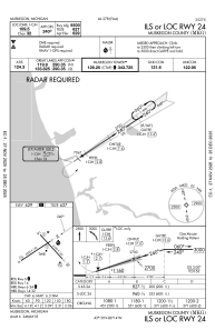
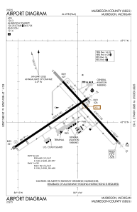


KMKG - Muskegon County
Located in Muskegon, United States
ICAO - MKG, IATA - MKG
Data provided by AirmateGeneral information
Coordinates: N43°10'4" W86°14'8"
Elevation is 628 feet MSL.
Magnetic variation is -04° East View others Airports in Michigan
Operational data
Special qualification required
Current time UTC:
Current local time:
Weather
METAR: KMKG 280455Z AUTO 20023G33KT 10SM CLR 18/14 A2993 RMK AO2 PK WND 21040/0426 SLP133 T01780139 402330133
TAF: KMKG 280551Z 2806/2906 21015G25KT P6SM -SHRA VCTS BKN040CB FM280700 21010KT 5SM -SHRA BR VCTS OVC008CB FM280900 22009KT 2SM BR VCSH OVC004 FM281700 16008KT 4SM -SHRA BR OVC006 FM281900 19010KT 6SM -SHRA BR OVC018 FM290400 12008KT 5SM -SHRA BR OVC015
Communications frequencies: [VIEW]
Runways:
| RWY identifier | QFU | Length (ft) | Width (ft) | Surface | LDA (ft) |
| 06 | 56° | 6501 | 150 | ASPH | 6501 |
| 24 | 236° | 6501 | 150 | ASPH | 6501 |
| 14 | 137° | 6100 | 150 | ASPH | 6100 |
| 32 | 317° | 6100 | 150 | ASPH | 6100 |
Airport contact information
Address: Muskegon United States
