


KMKG - Muskegon County
Located in Muskegon, United States
ICAO - MKG, IATA - MKG
Data provided by AirmateGeneral information
Coordinates: N43°10'4" W86°14'8"
Elevation is 628 feet MSL.
Magnetic variation is -04° East View others Airports in Michigan
Operational data
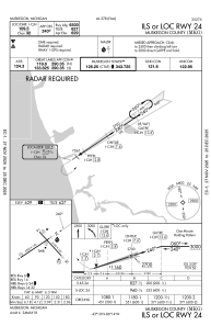
Special qualification required
Current time UTC:
Current local time:
Weather
METAR: KMKG 012255Z 25006KT 10SM SCT250 17/06 A2992 RMK AO2 SLP131 T01720056
Communications frequencies: [VIEW]
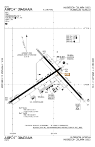
Runways:
| RWY identifier | QFU | Length (ft) | Width (ft) | Surface | LDA (ft) |
| 06 | 56° | 6501 | 150 | ASPH | 6501 |
| 24 | 236° | 6501 | 150 | ASPH | 6501 |
| 14 | 137° | 6100 | 150 | ASPH | 6100 |
| 32 | 317° | 6100 | 150 | ASPH | 6100 |
Airport contact information
Address: Muskegon United States
