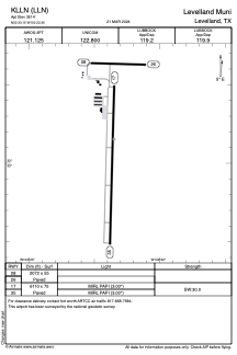


KLLN - Levelland Muni
Located in Levelland, United States
ICAO - LLN, IATA -
Data provided by AirmateGeneral information
Coordinates: N33°33'9" W102°22'21"
Elevation is 3514 feet MSL.
Magnetic variation is 09° East View others Airports in Texas
Operational data
Special qualification required
Current time UTC:
Current local time:
Weather at : KLBB - Lubbock Preston Smith Intl ( 53 km )
METAR: KLBB 171553Z 25007KT 10SM FEW008 FEW030 FEW150 SCT250 19/13 A2990 RMK AO2 SLP091 FU FEW008 E T01940133
TAF: KLBB 171120Z 1712/1812 27005KT P6SM SCT250 FM180100 16007KT P6SM SKC
Communications frequencies: [VIEW]
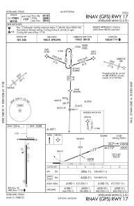
Runways:
| RWY identifier | QFU | Length (ft) | Width (ft) | Surface | LDA (ft) |
| 08 | 92° | 2072 | 55 | ASPH | |
| 26 | 272° | 2072 | 55 | ASPH | |
| 17 | 182° | 6110 | 75 | ASPH | |
| 35 | 2° | 6110 | 75 | ASPH |
Airport contact information
Address: Levelland United States