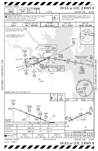
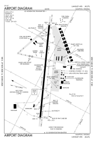


KLFI - Langley Afb
Located in Hampton, United States
ICAO - LFI, IATA - LFI
Data provided by AirmateGeneral information
Coordinates: N37°4'58" W76°21'38"
Elevation is 8 feet MSL.
Magnetic variation is -10° East View others Airports in Virginia
Operational data
Special qualification required
Current time UTC:
Current local time:
Weather
METAR: KLFI 130355Z 11004KT 10SM CLR 15/11 A3003 RMK AO2A SLP175 T01490113 $
TAF: TAF KLFI 130100Z 1301/1407 04009KT 9999 FEW020 QNH2995INS BECMG 1323/1324 13010G15KT 9999 FEW200 QNH3003INS TX24/1321Z TN14/1307Z
Communications frequencies: [VIEW]
Runways:
| RWY identifier | QFU | Length (ft) | Width (ft) | Surface | LDA (ft) |
| 08 | 0° | 10002 | 150 | CONC | |
| 26 | 0° | 10002 | 150 | CONC |
Airport contact information
Address: Hampton United States