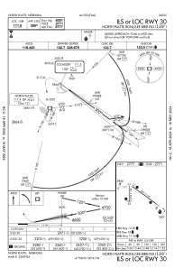
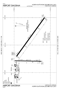


KLBF - North Platte Rgnl/Lee Bird Fld
Located in North Platte, United States
ICAO - LBF, IATA - LBF
Data provided by AirmateGeneral information
Coordinates: N41°7'34" W100°41'1"
Elevation is 2777 feet MSL.
Magnetic variation is 06° East View others Airports in Nebraska
Operational data
Special qualification required
Current time UTC:
Current local time:
Weather
METAR: KLBF 152053Z AUTO 00000KT 10SM BKN055 BKN075 BKN110 19/12 A2986 RMK AO2 LTG DSNT NE RAB27E51 SLP098 P0002 60002 T01940117 56013
TAF: KLBF 151720Z 1518/1618 34009KT P6SM BKN050 TEMPO 1520/1523 5SM -TSRA BKN035CB OVC050 FM160000 33010KT P6SM SCT200 FM160300 35003KT P6SM FEW250
Communications frequencies: [VIEW]
Runways:
| RWY identifier | QFU | Length (ft) | Width (ft) | Surface | LDA (ft) |
| 12 | 126° | 8001 | 150 | CONC | 8001 |
| 30 | 306° | 8001 | 150 | CONC | 8001 |
| 17 | 181° | 4436 | 100 | CONC | 4135 |
| 35 | 1° | 4436 | 100 | CONC | 4135 |
Airport contact information
Address: North Platte United States