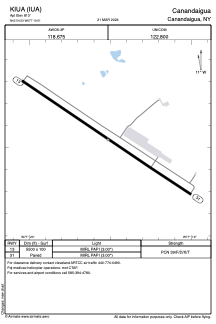


KIUA - Canandaigua
Located in Canandaigua, United States
ICAO - IUA, IATA -
Data provided by AirmateGeneral information
Coordinates: N42°54'32" W77°19'31"
Elevation is 813 feet MSL.
Magnetic variation is -12° East View others Airports in New York
Operational data
Special qualification required
Current time UTC:
Current local time:
Weather at : KROC - Frederick Douglass/Greater Rochester Intl ( 37 km )
METAR: KROC 111154Z 18006KT 10SM FEW270 09/07 A2979 RMK AO2 SLP093 T00940067 10094 20061 56001
TAF: KROC 111155Z 1112/1212 18006KT P6SM BKN250 FM111700 18008KT P6SM SCT050 BKN100 FM112100 18010KT 6SM -SHRA OVC040 FM120200 17006KT P6SM BKN040 FM120600 20006KT P6SM BKN025
Communications frequencies: [VIEW]
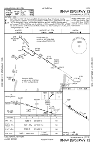
Runways:
| RWY identifier | QFU | Length (ft) | Width (ft) | Surface | LDA (ft) |
| 13 | 123° | 5500 | 100 | ASPH | |
| 31 | 303° | 5500 | 100 | ASPH |
Airport contact information
Address: Canandaigua United States