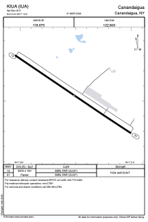


KIUA - Canandaigua
Located in Canandaigua, United States
ICAO - IUA, IATA -
Data provided by AirmateGeneral information
Coordinates: N42°54'32" W77°19'31"
Elevation is 813 feet MSL.
Magnetic variation is -12° East View others Airports in New York
Operational data
Special qualification required
Current time UTC:
Current local time:
Weather at : KROC - Frederick Douglass/Greater Rochester Intl ( 37 km )
METAR: KROC 280254Z 20009KT 10SM FEW075 SCT150 13/08 A3008 RMK AO2 SLP190 T01280083 58002
TAF: KROC 272330Z 2800/2824 20014G20KT P6SM SCT050 BKN090 FM280300 20014G20KT P6SM SCT050 SCT100 WS010/23040KT FM281100 22009KT P6SM SCT090 WS010/26040KT FM281300 24012G19KT P6SM VCSH BKN035 FM281500 25014G23KT 6SM -SHRA OVC015 FM282000 26013G23KT 6SM -SHRA OVC025 FM282200 26011G19KT P6SM OVC030
Communications frequencies: [VIEW]
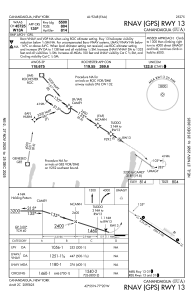
Runways:
| RWY identifier | QFU | Length (ft) | Width (ft) | Surface | LDA (ft) |
| 13 | 123° | 5500 | 100 | ASPH | |
| 31 | 303° | 5500 | 100 | ASPH |
Airport contact information
Address: Canandaigua United States