


KISP - Long Island Mac Arthur
Located in New York, United States
ICAO - ISP, IATA - ISP
Data provided by AirmateGeneral information
Coordinates: N40°47'46" W73°6'2"
Elevation is 98 feet MSL.
Magnetic variation is -14° East View others Airports in New York
Operational data
Special qualification required
Current time UTC:
Current local time:
Weather
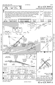
METAR: KISP 110456Z AUTO 33003KT 10SM OVC095 09/06 A2983 RMK AO2 SLP102 T00890056 401220089
TAF: KISP 110540Z 1106/1206 06005KT P6SM SCT060 BKN090 FM110900 03008KT P6SM SCT080 SCT120 FM111400 06009KT P6SM SCT050 FM111600 10011KT P6SM SCT050 SCT250 FM111900 15010KT P6SM SCT060 BKN250 FM120100 15006KT P6SM SCT030 BKN060
Communications frequencies: [VIEW]
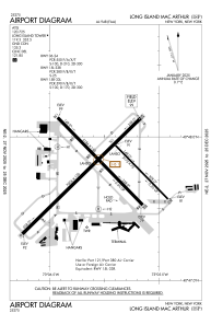
Runways:
| RWY identifier | QFU | Length (ft) | Width (ft) | Surface | LDA (ft) |
| 06 | 45° | 7006 | 150 | ASPH | 7006 |
| 24 | 225° | 7006 | 150 | ASPH | 7006 |
| 15L | 135° | 3175 | 75 | ASPH | 3175 |
| 33R | 315° | 3175 | 75 | ASPH | 3175 |
| 15R | 135° | 5186 | 150 | ASPH | 5186 |
| 33L | 315° | 5186 | 150 | ASPH | 5186 |
| H1 | 0° | 0 | 0 | UNK | |
| H2 | 0° | 0 | 0 | UNK |
Airport contact information
Address: New York United States
Other aviation service providers
Flight schools

Helicopter Flight Training, Inc.
Helicopter Flight Training, Inc.
easternhelicopte@aol.com+1(631)467-2232
Heritage Flight Academy, Llc
Heritage Flight Academy, Llc
info@heritageflightacademy.com+1(631)471-3550
Atp Flight School (800-All-Atps)
Atp Flight School (800-All-Atps)
info@atpflightschool.com+1(800)255-2877