


KISP - Long Island Mac Arthur
Located in New York, United States
ICAO - ISP, IATA - ISP
Data provided by AirmateGeneral information
Coordinates: N40°47'46" W73°6'2"
Elevation is 98 feet MSL.
Magnetic variation is -14° East View others Airports in New York
Operational data
Special qualification required
Current time UTC:
Current local time:
Weather
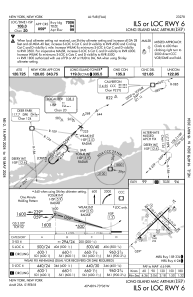
METAR: KISP 272256Z 22009KT 10SM -RA BKN050 BKN110 BKN160 OVC250 11/M01 A3041 RMK AO2 RAB50 SLP299 P0000 T01061006
TAF: KISP 272339Z 2800/2824 21011KT P6SM VCSH BKN050 OVC100 FM280400 18005KT P6SM -SHRA OVC030 FM280900 18007KT P6SM -SHRA OVC020 TEMPO 2810/2814 5SM BR OVC015 FM281400 20006KT P6SM BKN025 FM281700 20008KT P6SM BKN035
Communications frequencies: [VIEW]
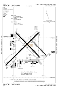
Runways:
| RWY identifier | QFU | Length (ft) | Width (ft) | Surface | LDA (ft) |
| 06 | 45° | 7006 | 150 | ASPH | 7006 |
| 24 | 225° | 7006 | 150 | ASPH | 7006 |
| 15R | 135° | 5186 | 150 | ASPH | 5186 |
| 33L | 315° | 5186 | 150 | ASPH | 5186 |
| 15L | 135° | 3175 | 75 | ASPH | 3175 |
| 33R | 315° | 3175 | 75 | ASPH | 3175 |
Airport contact information
Address: New York United States
Other aviation service providers
Flight schools

Helicopter Flight Training, Inc.
Helicopter Flight Training, Inc.
easternhelicopte@aol.com+1(631)467-2232
Heritage Flight Academy, Llc
Heritage Flight Academy, Llc
info@heritageflightacademy.com+1(631)471-3550
Atp Flight School (800-All-Atps)
Atp Flight School (800-All-Atps)
info@atpflightschool.com+1(800)255-2877