


KINT - Smith Reynolds
Located in Winston Salem, United States
ICAO - INT, IATA - INT
Data provided by AirmateGeneral information
Coordinates: N36°8'1" W80°13'19"
Elevation is 969 feet MSL.
Magnetic variation is -07° East View others Airports in North Carolina
Operational data
Special qualification required
Current time UTC:
Current local time:
Weather
METAR: KINT 161954Z VRB05KT 10SM SCT045 BKN050 27/14 A2982 RMK AO2 SLP087 T02670139
TAF: KINT 161736Z 1618/1718 VRB05KT P6SM BKN040 FM170000 VRB03KT P6SM SCT250 TEMPO 1709/1713 5SM BR
Communications frequencies: [VIEW]
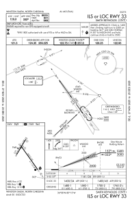
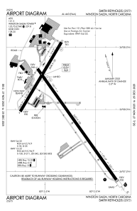
Runways:
| RWY identifier | QFU | Length (ft) | Width (ft) | Surface | LDA (ft) |
| 04 | 31° | 3938 | 150 | ASPH | 3938 |
| 22 | 211° | 3938 | 150 | ASPH | 3938 |
| 15 | 145° | 6655 | 150 | ASPH | 6069 |
| 33 | 325° | 6655 | 150 | ASPH | 6655 |
Airport contact information
Address: Winston Salem United States
