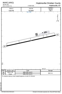


KHVC - Hopkinsville-Christian County
Located in Hopkinsville, United States
ICAO - HVC, IATA -
Data provided by AirmateGeneral information
Coordinates: N36°51'25" W87°27'18"
Elevation is 563 feet MSL.
Magnetic variation is -01° East View others Airports in Kentucky
Operational data
Special qualification required
Current time UTC:
Current local time:
Weather at : KHOP - Campbell Aaf (Fort Campbell) ( 21 km )
METAR: KHOP 160355Z AUTO 32003KT 9SM CLR 18/15 A2984 RMK AO2 SLP103 T01750151
TAF: TAF KHOP 160000Z 1600/1706 31006KT 9999 FEW025 BKN050 QNH2979INS BECMG 1605/1606 VRB06KT 9999 BKN025 OVC050 QNH2989INS BECMG 1609/1610 VRB06KT 4800 BR BKN005 OVC015 QNH2989INS TEMPO 1610/1613 0800 FG OVC003 BECMG 1614/1615 33009KT 9999 NSW BKN020 QNH2992INS BECMG 1618/1619 34006KT 9999 FEW075 QNH2983INS TX25/1620Z TN16/1610Z
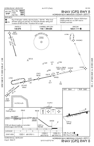
Communications frequencies: [VIEW]
Runways:
| RWY identifier | QFU | Length (ft) | Width (ft) | Surface | LDA (ft) |
| 08 | 78° | 5505 | 100 | ASPH | |
| 26 | 258° | 5505 | 100 | ASPH |
Airport contact information
Address: Hopkinsville United States