


KHOP - Campbell Aaf (Fort Campbell)
Located in Fort Campbell/Hopkinsville, United States
ICAO - HOP, IATA - HOP
Data provided by AirmateGeneral information
Coordinates: N36°40'23" W87°29'31"
Elevation is 571 feet MSL.
Magnetic variation is -01° East View others Airports in Kentucky
Operational data
Special qualification required
Current time UTC:
Current local time:
Weather
METAR: KHOP 290955Z AUTO 14005KT 10SM CLR 19/14 A2997 RMK AO2 SLP146 T01940140
TAF: TAF KHOP 290800Z 2908/3014 16009KT 9999 SCT040 510006 QNH2999INS BECMG 2913/2914 17015G25KT 9999 BKN030 510006 QNH2992INS TEMPO 2914/2917 18020G30KT BECMG 2918/2919 18012G20KT 9000 -SHRA BKN030 510006 QNH2978INS TEMPO 2923/3006 16015G30KT 8000 -TSRA BKN020CB BECMG 3005/3006 21015G25KT 4800 -SHRA OVC010 510006 QNH2977INS TX26/2918Z TN18/2911Z
Communications frequencies: [VIEW]
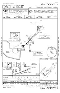
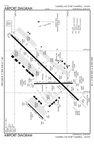
Runways:
| RWY identifier | QFU | Length (ft) | Width (ft) | Surface | LDA (ft) |
| 05 | 0° | 10926 | 150 | ASPH | |
| 23 | 0° | 10926 | 150 | ASPH | |
| 18 | 0° | 4500 | 100 | ASPH | |
| 36 | 0° | 4500 | 100 | ASPH |
Airport contact information
Address: Fort Campbell/Hopkinsville United States