


KGUR - Camp Guernsey
Located in Guernsey, United States
ICAO - GUR, IATA -
Data provided by AirmateGeneral information
Coordinates: N42°15'35" W104°43'42"
Elevation is 4401 feet MSL.
Magnetic variation is 11° East View others Airports in Wyoming
Operational data
Special qualification required
Current time UTC:
Current local time:
Weather
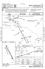
METAR: KGUR 092055Z AUTO 30005KT 10SM FEW021 BKN035 OVC048 10/06 A3023 RMK AO2 SLP255 60020 T00980061
TAF: TAF AMD KGUR 091800Z 0918/1019 34010G20KT 9000 -SHRA BKN010 OVC025 QNH3021INS TEMPO 0922/1002 8000 -TSRA BKN010CB BECMG 1004/1005 31006KT 9999 NSW BKN020 QNH3031INS TX10/0918Z TN06/1009Z
Communications frequencies: [VIEW]
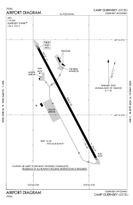
Runways:
| RWY identifier | QFU | Length (ft) | Width (ft) | Surface | LDA (ft) |
| 14 | 152° | 5060 | 90 | ASPH | |
| 32 | 332° | 5060 | 90 | ASPH |
Airport contact information
Address: Guernsey United States