


KGLD - Renner Fld/Goodland Muni
Located in Goodland, United States
ICAO - GLD, IATA - GLD
Data provided by AirmateGeneral information
Coordinates: N39°22'15" W101°41'55"
Elevation is 3657 feet MSL.
Magnetic variation is 09° East View others Airports in Kansas
Operational data
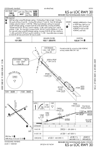
Special qualification required
Current time UTC:
Current local time:
Weather
METAR: KGLD 210231Z AUTO 11011KT 8SM FEW014 BKN020 BKN025 19/18 A2966 RMK AO2 T01890178
TAF: KGLD 202353Z 2100/2124 11015KT P6SM SCT025 SCT035 TEMPO 2100/2103 BKN025 FM210300 13015KT P6SM VCSH BKN050 TEMPO 2108/2112 VRB06KT 6SM BR OVC003 FM211200 33018G27KT P6SM BKN010 FM211800 33020G30KT P6SM BKN035
Communications frequencies: [VIEW]
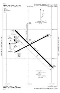
Runways:
| RWY identifier | QFU | Length (ft) | Width (ft) | Surface | LDA (ft) |
| 05 | 63° | 4001 | 75 | ASPH | |
| 23 | 243° | 4001 | 75 | ASPH | |
| 12 | 134° | 5499 | 100 | CONC | |
| 30 | 314° | 5499 | 100 | CONC | |
| 17 | 180° | 1754 | 40 | GRASS | |
| 35 | 360° | 1754 | 40 | GRASS |
Airport contact information
Address: Goodland United States
