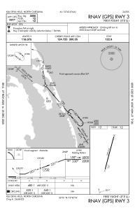
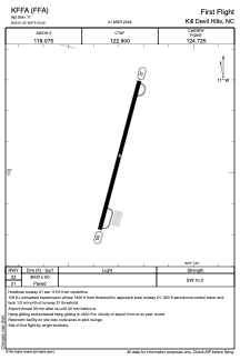


KFFA - First Flight
Located in Kill Devil Hills, United States
ICAO - FFA, IATA - FFA
Data provided by AirmateGeneral information
Coordinates: N36°1'3" W75°40'18"
Elevation is 11 feet MSL.
Magnetic variation is -11° East View others Airports in North Carolina
Operational data
Special qualification required
Current time UTC:
Current local time:
Weather
METAR: KFFA 161710Z AUTO 30007KT 10SM SCT033 21/14 A2973 RMK AO2 T02110142
Communications frequencies: [VIEW]
Runways:
| RWY identifier | QFU | Length (ft) | Width (ft) | Surface | LDA (ft) |
| 03 | 15° | 3000 | 60 | ASPH | |
| 21 | 195° | 3000 | 60 | ASPH |
Airport contact information
Address: Kill Devil Hills United States