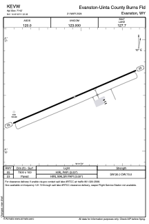


KEVW - Evanston-Uinta County Burns Fld
Located in Evanston, United States
ICAO - EVW, IATA - EVW
Data provided by AirmateGeneral information
Coordinates: N41°16'29" W111°2'5"
Elevation is 7142 feet MSL.
Magnetic variation is 13° East View others Airports in Wyoming
Operational data
Special qualification required
Current time UTC:
Current local time:
Weather
METAR: KEVW 130153Z AUTO 28009KT 10SM CLR 17/M02 A3006 RMK AO2 SLP112 T01671022 $
TAF: KEVW 130157Z 1302/1324 28010KT P6SM SCT100 FM130300 21005KT P6SM SKC FM131700 28011G18KT P6SM SKC
Communications frequencies: [VIEW]
Runways:
| RWY identifier | QFU | Length (ft) | Width (ft) | Surface | LDA (ft) |
| 05 | 66° | 7300 | 100 | ASPH | |
| 23 | 246° | 7300 | 100 | ASPH |
Airport contact information
Address: Evanston United States
