


KEND - Vance Afb
Located in Enid, United States
ICAO - END, IATA - END
Data provided by AirmateGeneral information
Coordinates: N36°20'23" W97°55'2"
Elevation is 1312 feet MSL.
Magnetic variation is 05° East View others Airports in Oklahoma
Operational data
Special qualification required
Current time UTC:
Current local time:
Weather
METAR: KEND 082155Z AUTO 01012KT 10SM CLR 27/06 A2957 RMK AO2 SLP005 T02680062 $
TAF: TAF KEND 081800Z 0818/0924 35015G25KT 9999 SKC QNH2958INS BECMG 0900/0901 35010KT 9999 SKC QNH2975INS BECMG 0908/0909 04010KT 9999 SKC QNH2955INS BECMG 0917/0918 36012G18KT 9999 SCT120 QNH3000INS TX28/0820Z TN09/0911Z
Communications frequencies: [VIEW]
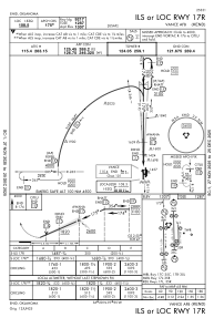
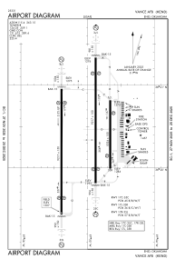
Runways:
| RWY identifier | QFU | Length (ft) | Width (ft) | Surface | LDA (ft) |
| 17C | 180° | 9217 | 150 | OTHER | |
| 35C | 360° | 9217 | 150 | OTHER | |
| 17L | 180° | 5024 | 150 | CONC | |
| 35R | 360° | 5024 | 150 | CONC | |
| 17R | 180° | 9217 | 150 | OTHER | |
| 35L | 360° | 9217 | 150 | OTHER |
Airport contact information
Address: Enid United States