


KEND - Vance Afb
Located in Enid, United States
ICAO - END, IATA - END
Data provided by AirmateGeneral information
Coordinates: N36°20'23" W97°55'2"
Elevation is 1312 feet MSL.
Magnetic variation is 05° East View others Airports in Oklahoma
Operational data
Special qualification required
Current time UTC:
Current local time:
Weather
METAR: KEND 192257Z 17020G27KT 10SM FEW046 FEW170 31/20 A2970 RMK PK WND 17031/24 SLPNO
TAF: TAF KEND 191800Z 1918/2100 15015G28KT 9999 SCT150 QNH2982INS BECMG 2005/2006 15015G20KT 6000 -SHRA BR BKN020 QNH2980INS TEMPO 2006/2010 16020G40KT 6000 TSRA BR OVC015CB BECMG 2010/2011 16015G20KT 9999 NSW SCT050 QNH2976INS TX33/1919Z TN18/2009Z
Communications frequencies: [VIEW]
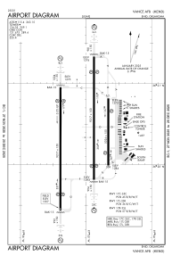
Runways:
| RWY identifier | QFU | Length (ft) | Width (ft) | Surface | LDA (ft) |
| 17C | 180° | 9217 | 150 | OTHER | |
| 35C | 360° | 9217 | 150 | OTHER | |
| 17L | 180° | 5024 | 150 | CONC | |
| 35R | 360° | 5024 | 150 | CONC | |
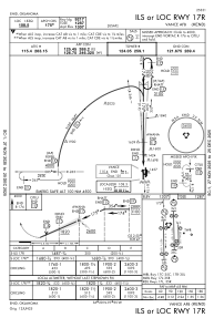
| 17R | 180° | 9217 | 150 | OTHER | |
| 35L | 360° | 9217 | 150 | OTHER |
Airport contact information
Address: Enid United States