


KDYS - Dyess Afb
Located in Abilene, United States
ICAO - DYS, IATA - DYS
Data provided by AirmateGeneral information
Coordinates: N32°25'7" W99°51'24"
Elevation is 1790 feet MSL.
Magnetic variation is 05° East View others Airports in Texas
Operational data
Special qualification required
Current time UTC:
Current local time:
Weather
METAR: KDYS 161408Z 07007KT 10SM TS OVC031 18/17 A2978 RMK AO2A RAE03 TSB08 SLP046
TAF: TAF AMD KDYS 161247Z 1612/1717 VRB12G18KT 8000 -TSRA BR BKN005CB QNH2972INS TEMPO 1619/1623 VRB25G35KT 6000 TSRA OVC010CB BECMG 1700/1701 VRB06KT 9999 NSW OVC030 QNH2966INS BECMG 1702/1703 VRB06KT 9000 -SHRA OVC030 QNH2969INS TEMPO 1702/1704 VRB15G25KT 8000 -TSRA OVC020CB BECMG 1704/1705 VRB06KT 9999 NSW BKN030 QNH2970INS BECMG 1708/1709 VRB06KT 9999 BKN050 QNH2969INS BECMG 1715/1716 28009KT 9999 SCT080 QNH2974INS TX23/1620Z TN18/1711Z
Communications frequencies: [VIEW]
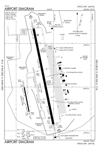
Runways:
| RWY identifier | QFU | Length (ft) | Width (ft) | Surface | LDA (ft) |
| 16 | 0° | 13500 | 300 | OTHER | |
| 34 | 0° | 13500 | 300 | OTHER | |
| 163 | 0° | 3500 | 60 | OTHER | |
| 343 | 0° | 3500 | 60 | OTHER | |
| 164 | 0° | 3498 | 60 | ASPH | |
| 344 | 0° | 3498 | 60 | ASPH |
Airport contact information
Address: Abilene United States