


KDMN - Deming Muni
Located in Deming, United States
ICAO - DMN, IATA - DMN
Data provided by AirmateGeneral information
Coordinates: N32°15'45" W107°43'8"
Elevation is 4314 feet MSL.
Magnetic variation is 10° East View others Airports in New Mexico
Operational data
Special qualification required
Current time UTC:
Current local time:
Weather
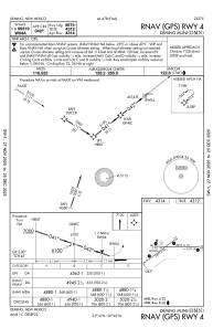
METAR: KDMN 112153Z AUTO 24019G34KT 10SM CLR 30/M12 A2982 RMK AO2 PK WND 25037/2116 SLP026 T03001122
TAF: KDMN 111720Z 1118/1218 24012G20KT P6SM SKC FM112100 25015G25KT P6SM SKC FM120300 29008KT P6SM SKC
Communications frequencies: [VIEW]
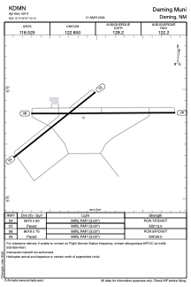
Runways:
| RWY identifier | QFU | Length (ft) | Width (ft) | Surface | LDA (ft) |
| 04 | 52° | 5675 | 60 | ASPH | |
| 22 | 232° | 5675 | 60 | ASPH | |
| 08 | 90° | 8018 | 75 | ASPH | |
| 26 | 270° | 8018 | 75 | ASPH |
Airport contact information
Address: Deming United States