


KDLH - Duluth Intl
Located in Duluth, United States
ICAO - DLH, IATA - DLH
Data provided by AirmateGeneral information
Coordinates: N46°50'31" W92°11'36"
Elevation is 1427 feet MSL.
Magnetic variation is -01° East View others Airports in Minnesota
Operational data
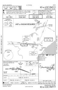
Special qualification required
Current time UTC:
Current local time:
Weather
METAR: KDLH 192155Z 22013G18KT 10SM SCT110 21/03 A2996 RMK AO2 SLP149 T02060033 $
TAF: KDLH 191738Z 1918/2018 26012G15KT P6SM BKN110 FM192100 23009KT P6SM BKN120 FM201000 10006KT P6SM -SHRA OVC025 FM201200 10007KT 5SM -SHRA BR OVC011 FM201400 09007KT 2SM -SHRA BR OVC009
Communications frequencies: [VIEW]
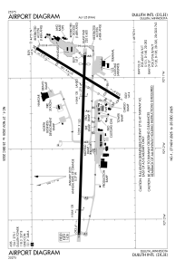
Runways:
| RWY identifier | QFU | Length (ft) | Width (ft) | Surface | LDA (ft) |
| 03 | 32° | 5719 | 150 | ASPH | 5719 |
| 21 | 212° | 5719 | 150 | ASPH | 5719 |
| 09 | 92° | 10591 | 150 | CONC | 10062 |
| 27 | 272° | 10591 | 150 | CONC | 10062 |
Airport contact information
Address: Duluth United States
