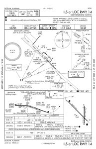
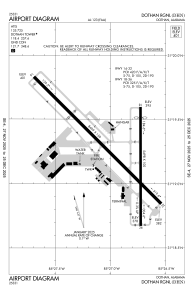


KDHN - Dothan Rgnl
Located in Dothan, United States
ICAO - DHN, IATA - DHN
Data provided by AirmateGeneral information
Coordinates: N31°19'16" W85°26'58"
Elevation is 400 feet MSL.
Magnetic variation is -03° East View others Airports in Alabama
Operational data
Special qualification required
Current time UTC:
Current local time:
Weather
METAR: KDHN 150253Z AUTO 20006KT 10SM SCT021 BKN026 BKN080 24/22 A2979 RMK AO2 SLP083 T02390217 51009
TAF: KDHN 142323Z 1500/1524 22009KT P6SM VCSH FEW025 BKN040 FM150300 27008KT P6SM BKN035 TEMPO 1507/1510 BKN025 FM151000 27011KT P6SM SCT250
Communications frequencies: [VIEW]
Runways:
| RWY identifier | QFU | Length (ft) | Width (ft) | Surface | LDA (ft) |
| 14 | 135° | 8499 | 150 | ASPH | 8496 |
| 32 | 315° | 8499 | 150 | ASPH | 8496 |
| 18 | 180° | 5498 | 100 | ASPH | 5000 |
| 36 | 360° | 5498 | 100 | ASPH | 5000 |
Airport contact information
Address: Dothan United States
