


KCVS - Cannon Afb
Located in Clovis, United States
ICAO - CVS, IATA - CVS
Data provided by AirmateGeneral information
Coordinates: N34°22'58" W103°19'20"
Elevation is 4295 feet MSL.
Magnetic variation is 07° East View others Airports in New Mexico
Operational data
Special qualification required
Current time UTC:
Current local time:
Weather
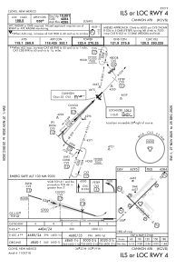
METAR: KCVS 120632Z 12006KT 3SM -DZ BR OVC003 13/12 A2997 RMK AO2A DZB0558E04RAB04E14RAB27E29DZB29 SLP114 FZRANO $
Communications frequencies: [VIEW]
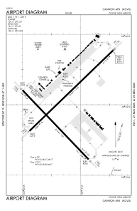
Runways:
| RWY identifier | QFU | Length (ft) | Width (ft) | Surface | LDA (ft) |
| 04 | 45° | 10003 | 150 | CONC | |
| 22 | 225° | 10003 | 150 | CONC | |
| 13 | 135° | 8196 | 150 | OTHER | |
| 31 | 315° | 8196 | 150 | OTHER |
Airport contact information
Address: Clovis United States