


KCOS - City Of Colorado Springs Muni
Located in Colorado Springs, United States
ICAO - COS, IATA - COS
Data provided by AirmateGeneral information
Coordinates: N38°48'21" W104°42'3"
Elevation is 6187 feet MSL.
Magnetic variation is 08° East View others Airports in Colorado
Operational data
Special qualification required
Current time UTC:
Current local time:
Weather
METAR: KCOS 081654Z 33012G21KT 10SM FEW090 11/M14 A2978 RMK AO2 PK WND 30029/1608 SLP044 T01111144
TAF: KCOS 081122Z 0812/0912 33010KT P6SM FEW100 FM081400 33012G24KT P6SM FEW100 FM081900 35012KT P6SM SCT080 FM082300 36010KT P6SM BKN080
Communications frequencies: [VIEW]
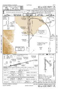
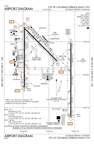
Runways:
| RWY identifier | QFU | Length (ft) | Width (ft) | Surface | LDA (ft) |
| 13 | 135° | 8270 | 150 | ASPH | 8270 |
| 31 | 315° | 8270 | 150 | ASPH | 7914 |
| 17L | 180° | 13500 | 150 | CONC | 13501 |
| 35R | 0° | 13500 | 150 | CONC | 13501 |
| 17R | 180° | 11022 | 150 | ASPH | 11022 |
| 35L | 0° | 11022 | 150 | ASPH | 11022 |
Airport contact information
Address: Colorado Springs United States

