


KCEF - Westover Arb/Metro
Located in Springfield/Chicopee, United States
ICAO - CEF, IATA - CEF
Data provided by AirmateGeneral information
Coordinates: N42°11'38" W72°32'5"
Elevation is 241 feet MSL.
Magnetic variation is -14° East View others Airports in Massachusetts
Operational data
Special qualification required
Current time UTC:
Current local time:
Weather
METAR: KCEF 152055Z 08005KT 10SM -RA FEW013 SCT028 BKN041 BKN100 18/16 A2982 RMK AO2A SLP103 P0000 60001 T01810159 57012
TAF: TAF COR KCEF 151714Z 1517/1623 VRB06KT 9999 -RA SCT022 BKN035 OVC070 620902 QNH2985INS BECMG 1517/1518 VRB06KT 9999 -RA BKN015 OVC035 620902 QNH2984INS TEMPO 1518/1522 8000 -RA BR BKN020 OVC050 BECMG 1521/1522 VRB06KT 9999 NSW FEW020 OVC070 QNH2980INS BECMG 1604/1605 05009KT 9999 -RA BKN015 OVC060 QNH2979INS BECMG 1607/1608 05012KT 4800 -RA BR SCT007 OVC012 510103 QNH2979INS TEMPO 1613/1621 05012G20KT 8000 -RA BR 520004 BECMG 1620/1621 03012KT 9999 -RA SCT030 OVC050 510103 QNH2986INS TX21/1522Z TN14/1610Z
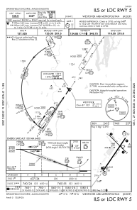
Communications frequencies: [VIEW]
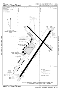
Runways:
| RWY identifier | QFU | Length (ft) | Width (ft) | Surface | LDA (ft) |
| 05 | 34° | 11597 | 300 | ASPH | |
| 23 | 214° | 11597 | 300 | ASPH | |
| 15 | 135° | 7085 | 150 | ASPH | |
| 33 | 315° | 7085 | 150 | ASPH |
Airport contact information
Address: Springfield/Chicopee United States