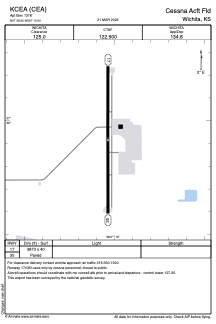


KCEA - Cessna Acft Fld
Located in Wichita, United States
ICAO - CEA, IATA - CEA
Data provided by AirmateGeneral information
Coordinates: N37°38'55" W97°15'2"
Elevation is 1378 feet MSL.
Magnetic variation is 08° East View others Airports in Kansas
Operational data
Special qualification required
Current time UTC:
Current local time:
Weather at : KIAB - Mc Connell Afb ( 3 km )
TAF: TAF KIAB 251000Z 2510/2616 10006KT 9999 FEW250 QNH2985INS BECMG 2512/2513 12012G18KT 9999 FEW250 QNH2983INS BECMG 2517/2518 16015G25KT 9999 FEW250 QNH2959INS BECMG 2523/2524 17012G18KT 9999 SCT050 QNH2958INS BECMG 2602/2603 15012G18KT 9000 -SHRA VCTS BKN050CB QNH2947INS TEMPO 2604/2607 VRB30G45KT 3200 TSRAGR BKN030CB OVC050 BECMG 2607/2608 18012G20KT 9999 VCSH BKN015 QNH2944INS BECMG 2610/2611 20012G18KT 9999 NSW SCT020 QNH2945INS BECMG 2613/2614 29012G18KT 9999 SKC QNH2948INS TX29/2522Z TN13/2512Z
Communications frequencies: [VIEW]
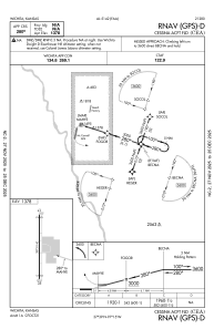
Runways:
| RWY identifier | QFU | Length (ft) | Width (ft) | Surface | LDA (ft) |
| 17 | 180° | 3873 | 40 | ASPH | |
| 35 | 0° | 3873 | 40 | ASPH |
Airport contact information
Address: Wichita United States