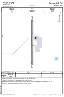


KCEA - Cessna Acft Fld
Located in Wichita, United States
ICAO - CEA, IATA - CEA
Data provided by AirmateGeneral information
Coordinates: N37°38'55" W97°15'2"
Elevation is 1378 feet MSL.
Magnetic variation is 08° East View others Airports in Kansas
Operational data
Special qualification required
Current time UTC:
Current local time:
Weather at : KIAB - Mc Connell Afb ( 3 km )
METAR: KIAB 210355Z AUTO 17013KT 10SM FEW230 25/19 A2970 RMK AO2 SLP047 T02500189
TAF: TAF KIAB 201800Z 2018/2124 20015G22KT 9999 BKN035 QNH2970INS BECMG 2023/2024 19012KT 9999 BKN050 QNH2965INS BECMG 2103/2104 18012KT 9999 SCT020 WS020/19045KT QNH2961INS BECMG 2108/2109 17012KT 9999 FEW007 BKN012 WS020/20050KT QNH2960INS TEMPO 2110/2114 17014G22KT OVC007 BECMG 2115/2116 21015G25KT 9999 FEW030 SCT180 QNH2960INS BECMG 2120/2121 29015G22KT 9999 SKC 520304 QNH2967INS TX29/2021Z TN21/2112Z
Communications frequencies: [VIEW]
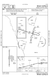
Runways:
| RWY identifier | QFU | Length (ft) | Width (ft) | Surface | LDA (ft) |
| 17 | 180° | 3873 | 40 | ASPH | |
| 35 | 0° | 3873 | 40 | ASPH |
Airport contact information
Address: Wichita United States