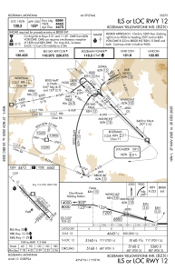
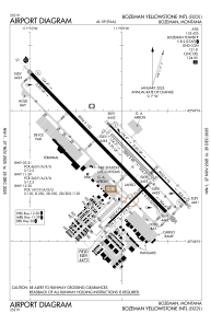


KBZN - Bozeman Yellowstone Intl
Located in Bozeman, United States
ICAO - BZN, IATA - BZN
Data provided by AirmateGeneral information
Coordinates: N45°46'38" W111°9'1"
Elevation is 4473 feet MSL.
Magnetic variation is 13° East View others Airports in Montana
Operational data
Special qualification required
Current time UTC:
Current local time:
Weather
METAR: KBZN 220656Z AUTO 15007KT 10SM OVC095 07/M01 A2987 RMK AO2 SLP106 T00671006 401500011
TAF: KBZN 220520Z 2206/2312 VRB06KT P6SM OVC080 FM221500 21008KT P6SM BKN040 PROB30 2222/2302 5SM -TSRA OVC035CB FM230300 VRB06KT 5SM -RA OVC010 PROB30 2306/2312 3/4SM -SN OVC005
Communications frequencies: [VIEW]
Runways:
| RWY identifier | QFU | Length (ft) | Width (ft) | Surface | LDA (ft) |
| 03 | 46° | 2650 | 75 | ASPH | 2650 |
| 21 | 226° | 2650 | 75 | ASPH | 2650 |
| 11 | 136° | 5050 | 75 | ASPH | 5050 |
| 29 | 316° | 5050 | 75 | ASPH | 5050 |
| 11G | 136° | 2802 | 80 | GRASS | |
| 29G | 316° | 2802 | 80 | GRASS | |
| 12 | 136° | 8994 | 150 | ASPH | 8994 |
| 30 | 316° | 8994 | 150 | ASPH | 8994 |
Airport contact information
Address: Bozeman United States

