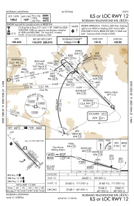
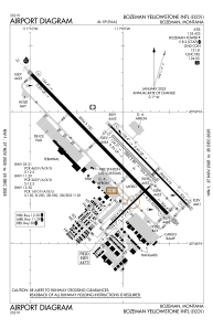


KBZN - Bozeman Yellowstone Intl
Located in Bozeman, United States
ICAO - BZN, IATA - BZN
Data provided by AirmateGeneral information
Coordinates: N45°46'38" W111°9'1"
Elevation is 4473 feet MSL.
Magnetic variation is 13° East View others Airports in Montana
Operational data
Special qualification required
Current time UTC:
Current local time:
Weather
METAR: KBZN 020056Z 30004KT 10SM FEW075 BKN095 04/M05 A2995 RMK AO2 PK WND 28034/0008 RAB13E24 SLP162 P0000 T00441050
TAF: KBZN 012320Z 0200/0306 32011KT P6SM BKN060 TEMPO 0200/0203 6SM -SHSNRA BKN030 FM020800 22010KT P6SM SCT040 BKN060 PROB30 0209/0212 5SM -SHSN OVC030 FM021900 29009KT P6SM SCT040 BKN060
Communications frequencies: [VIEW]
Runways:
| RWY identifier | QFU | Length (ft) | Width (ft) | Surface | LDA (ft) |
| 03 | 46° | 2650 | 75 | ASPH | 2650 |
| 21 | 226° | 2650 | 75 | ASPH | 2650 |
| 11 | 136° | 5050 | 75 | ASPH | 5050 |
| 29 | 316° | 5050 | 75 | ASPH | 5050 |
| 11G | 136° | 2802 | 80 | GRASS | |
| 29G | 316° | 2802 | 80 | GRASS | |
| 12 | 136° | 8994 | 150 | ASPH | 8994 |
| 30 | 316° | 8994 | 150 | ASPH | 8994 |
Airport contact information
Address: Bozeman United States

