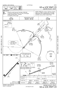
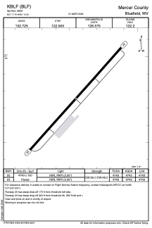


KBLF - Mercer County
Located in Bluefield, United States
ICAO - BLF, IATA - BLF
Data provided by AirmateGeneral information
Coordinates: N37°17'45" W81°12'27"
Elevation is 2856 feet MSL.
Magnetic variation is -07° East View others Airports in West Virginia
Operational data
Special qualification required
Current time UTC:
Current local time:
Weather
METAR: KBLF 161219Z AUTO 30004KT 2SM BR OVC002 13/13 A2990 RMK AO2 VIS 1 1/2V3 T01280128
TAF: KBLF 161120Z 1612/1712 VRB03KT 1/4SM FG OVC001 FM161300 28005KT 2SM BR BKN003 FM161400 30005KT P6SM SCT007 OVC015 FM161800 30007KT P6SM -TSRA BKN035CB FM162200 28004KT P6SM SCT100 SCT250 FM170700 24003KT 1/4SM FG OVC002
Communications frequencies: [VIEW]
Runways:
| RWY identifier | QFU | Length (ft) | Width (ft) | Surface | LDA (ft) |
| 05 | 42° | 4743 | 100 | ASPH | 4743 |
| 23 | 222° | 4743 | 100 | ASPH | 4743 |
Airport contact information
Address: Bluefield United States
