


KAUG - Augusta State
Located in Augusta, United States
ICAO - AUG, IATA - AUG
Data provided by AirmateGeneral information
Coordinates: N44°19'14" W69°47'50"
Elevation is 351 feet MSL.
Magnetic variation is -18° East View others Airports in Maine
Operational data
Special qualification required
Current time UTC:
Current local time:
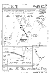
Weather
TAF: KAUG 171730Z 1718/1818 06008KT P6SM FEW050 SCT060 FM171900 12010KT P6SM SCT050 SCT250 FM172300 15008KT P6SM FEW060 SCT250 FM181200 03003KT P6SM VCSH BKN050
Communications frequencies: [VIEW]
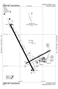
Runways:
| RWY identifier | QFU | Length (ft) | Width (ft) | Surface | LDA (ft) |
| 08 | 62° | 2613 | 75 | ASPH | 2613 |
| 26 | 242° | 2613 | 75 | ASPH | 2613 |
| 17 | 153° | 5002 | 100 | ASPH | 5002 |
| 35 | 333° | 5002 | 100 | ASPH | 5002 |
Airport contact information
Address: Augusta United States
