


KAUG - Augusta State
Located in Augusta, United States
ICAO - AUG, IATA - AUG
Data provided by AirmateGeneral information
Coordinates: N44°19'14" W69°47'50"
Elevation is 351 feet MSL.
Magnetic variation is -18° East View others Airports in Maine
Operational data
Special qualification required
Current time UTC:
Current local time:
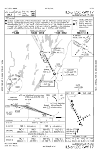
Weather
METAR: KAUG 030546Z AUTO 32004KT 1SM BR SCT003 OVC048 08/07 A3013 RMK AO2 T00780072
TAF: KAUG 030530Z 0306/0406 34004KT 1/2SM FG BKN003 OVC050 FM031100 VRB04KT P6SM BKN012 FM031400 02008KT P6SM BKN025 FM031700 01007KT P6SM BKN035 FM040000 VRB03KT 6SM BR SCT050
Communications frequencies: [VIEW]
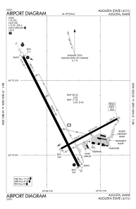
Runways:
| RWY identifier | QFU | Length (ft) | Width (ft) | Surface | LDA (ft) |
| 08 | 62° | 2613 | 75 | ASPH | 2613 |
| 26 | 242° | 2613 | 75 | ASPH | 2613 |
| 17 | 153° | 5002 | 100 | ASPH | 5002 |
| 35 | 333° | 5002 | 100 | ASPH | 5002 |
Airport contact information
Address: Augusta United States
