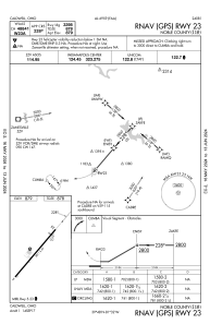
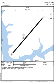


I10 - Noble County
Located in Caldwell, United States
ICAO - I10, IATA -
Data provided by AirmateGeneral information
Coordinates: N39°48'3" W81°32'11"
Elevation is 879 feet MSL.
Magnetic variation is -07° East View others Airports in Ohio
Operational data
Special qualification required
Current time UTC:
Current local time:
Weather at : KCDI - Cambridge Muni ( 20 km )
METAR: KCDI 171455Z AUTO 20004KT 4SM RA BKN007 BKN025 OVC033 18/18 A2990 RMK AO2 T01800176
Communications frequencies: [VIEW]
Runways:
| RWY identifier | QFU | Length (ft) | Width (ft) | Surface | LDA (ft) |
| 05 | 41° | 3811 | 65 | ASPH | |
| 23 | 221° | 3811 | 65 | ASPH |
Airport contact information
Address: Caldwell United States