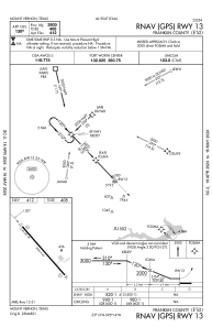
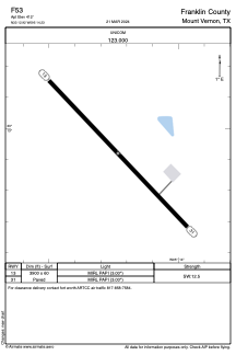


F53 - Franklin County
Located in Mount Vernon, United States
ICAO - F53, IATA -
Data provided by AirmateGeneral information
Coordinates: N33°12'55" W95°14'14"
Elevation is 412 feet MSL.
Magnetic variation is 06° East View others Airports in Texas
Operational data
Special qualification required
Current time UTC:
Current local time:
Weather at : KOSA - Mount Pleasant Rgnl ( 29 km )
METAR: KOSA 162315Z AUTO 07008KT 2 1/2SM -RA BR SCT070 SCT095 OVC110 19/ A2972 RMK AO2 VIS 1 1/2V3 1/2 P0001 T0194////
Communications frequencies: [VIEW]
Runways:
| RWY identifier | QFU | Length (ft) | Width (ft) | Surface | LDA (ft) |
| 13 | 136° | 3900 | 60 | ASPH | |
| 31 | 316° | 3900 | 60 | ASPH |
Airport contact information
Address: Mount Vernon United States