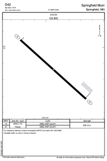


D42 - Springfield Muni
Located in Springfield, United States
ICAO - D42, IATA -
Data provided by AirmateGeneral information
Coordinates: N44°13'52" W94°59'56"
Elevation is 1073 feet MSL.
Magnetic variation is 02° East View others Airports in Minnesota
Operational data
Special qualification required
Current time UTC:
Current local time:
Weather at : KRWF - Redwood Falls Muni ( 36 km )
METAR: KRWF 142153Z AUTO 07009KT 7SM CLR 24/02 A2979 RMK AO2 SLP088 T02390022
TAF: KRWF 141720Z 1418/1518 10008KT P6SM FEW250 FM151200 13009KT P6SM BKN100 FM151400 14011KT P6SM OVC050
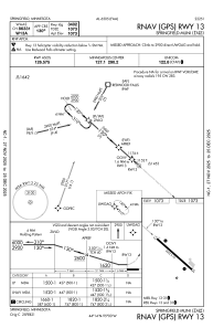
Communications frequencies: [VIEW]
Runways:
| RWY identifier | QFU | Length (ft) | Width (ft) | Surface | LDA (ft) |
| 13 | 132° | 3402 | 75 | ASPH | |
| 31 | 312° | 3402 | 75 | ASPH |
Airport contact information
Address: Springfield United States