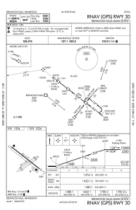
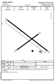


KRWF - Redwood Falls Muni
Located in Redwood Falls, United States
ICAO - RWF, IATA -
Data provided by AirmateGeneral information
Coordinates: N44°32'49" W95°4'55"
Elevation is 1023 feet MSL.
Magnetic variation is 04° East View others Airports in Minnesota
Operational data
Special qualification required
Current time UTC:
Current local time:
Weather
METAR: KRWF 301053Z AUTO 12003KT 9SM FEW110 04/03 A2984 RMK AO2 SLP110 T00390033
TAF: KRWF 300539Z 3006/0106 24005KT P6SM FEW040 FM300800 20004KT P6SM SCT040 FM301300 14009KT P6SM BKN150 FM302100 14014G22KT 2SM -TSRA OVC030CB FM010100 27015G24KT 6SM BR OVC250
Communications frequencies: [VIEW]
Runways:
| RWY identifier | QFU | Length (ft) | Width (ft) | Surface | LDA (ft) |
| 05 | 54° | 2081 | 200 | GRASS | |
| 23 | 234° | 2081 | 200 | GRASS | |
| 12 | 128° | 4001 | 100 | ASPH | |
| 30 | 308° | 4001 | 100 | ASPH |
Airport contact information
Address: Redwood Falls United States