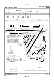


CYNJ - Langley Regional
Located in , Canada
ICAO - CYNJ, IATA - YLY
Data provided by AirmateGeneral information
Coordinates: N49°6'3" W122°37'51"
Elevation is 34 feet MSL.
Magnetic variation is 16.83° East View others Airports in British Columbia
Operational data
Special qualification required
Current time UTC:
Current local time:
Weather at : CYXX - Abbotsford ( 21 km )
METAR: CYXX 112000Z 22007KT 30SM FEW200 FEW250 23/11 A2993 RMK CC1CI1 SLP139 DENSITY ALT 1200FT
TAF: TAF CYXX 111740Z 1118/1218 14005KT P6SM FEW220 BECMG 1118/1120 22010KT BECMG 1203/1205 VRB03KT RMK NXT FCST BY 120000Z
Communications frequencies: [VIEW]
Runways:
| RWY identifier | QFU | Length (ft) | Width (ft) | Surface | LDA (ft) |
| 01 | 32° | 2100 | 75 | ASPH | 1996 |
| 19 | 212° | 2100 | 75 | ASPH | 2004 |
| 07 | 91° | 2743 | 75 | ASPH | 2089 |
| 25 | 271° | 2743 | 75 | ASPH | 2400 |
Airport contact information
Address: Canada
Other aviation service providers
Flight schools

Langley Flying School Inc.
Langley Flying School Inc.
administration@langleyflyingschool.com+16045326461