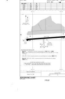


CYDQ - Dawson Creek
Located in , Canada
ICAO - CYDQ, IATA - YDQ
Data provided by AirmateGeneral information
Coordinates: N55°44'32" W120°10'59"
Elevation is 2147 feet MSL.
Magnetic variation is 18.2411° East View others Airports in British Columbia
Operational data
Special qualification required
Current time UTC:
Current local time:
Weather
METAR: CYDQ 281600Z AUTO 27012G17KT 9SM CLR 09/01 A2962 RMK SLP050 DENSITY ALT 2400FT
TAF: TAF AMD CYDQ 281408Z 2814/2901 26017G27KT P6SM SCT040 BKN080 TEMPO 2814/2901 P6SM -SHRA BKN040 BKN080 BECMG 2816/2818 25008KT RMK FCST BASED ON AUTO OBS. NXT FCST BY 281900Z
Communications frequencies: [VIEW]
Runways:
| RWY identifier | QFU | Length (ft) | Width (ft) | Surface | LDA (ft) |
| 07 | 86° | 5001 | 150 | ASPH | 5001 |
| 25 | 266° | 5001 | 150 | ASPH | 5001 |
Airport contact information
Address: Canada