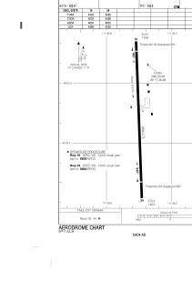


CAD4 - Trail
Located in , Canada
ICAO - CAD4, IATA - YZZ
Data provided by AirmateGeneral information
Coordinates: N49°3'36" W117°36'29"
Elevation is 1427 feet MSL.
Magnetic variation is 15.555° East View others Airports in British Columbia
Operational data
Special qualification required
Current time UTC:
Current local time:
Weather at : CYCG - West Kootenay Regional ( 26 km )
METAR: CYCG 041900Z 36007KT 15SM FEW120 OVC230 16/03 A2967 RMK AC2CS6 SLP052 DENSITY ALT 2500FT
TAF: TAF CYCG 041840Z 0419/0504 34008KT P6SM SCT120 BKN240 FM050000 01006KT P6SM BKN080 RMK NXT FCST BY 050100Z
Communications frequencies: [VIEW]
Runways:
| RWY identifier | QFU | Length (ft) | Width (ft) | Surface | LDA (ft) |
| 16 | 178° | 4001 | 75 | ASPH | 4001 |
| 34 | 358° | 4001 | 75 | ASPH | 4001 |
Airport contact information
Address: Canada