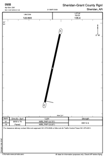


9M8 - Sheridan-Grant County Rgnl
Located in Sheridan, United States
ICAO - 9M8, IATA -
Data provided by AirmateGeneral information
Coordinates: N34°19'39" W92°21'5"
Elevation is 236 feet MSL.
Magnetic variation is 00° East View others Airports in Arkansas
Operational data
Special qualification required
Current time UTC:
Current local time:
Weather at : KPBF - Pinebluff Rgnl/Grider Fld ( 42 km )
METAR: KPBF 132353Z AUTO 15004KT 10SM FEW024 OVC033 24/20 A2970 RMK AO2 SLPNO T02440200 10250 20239 58003
TAF: KPBF 140000Z 1400/1424 VRB05KT P6SM VCSH SCT025 BKN040 FM140300 VRB04KT P6SM VCTS SCT020CB BKN050 TEMPO 1404/1408 4SM -SHRA BR BKN020 FM140800 22005KT P6SM BKN050 OVC100 TEMPO 1410/1414 5SM BR BKN015 FM141500 26012G20KT P6SM SCT035 BKN060
Communications frequencies: [VIEW]
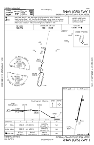
Runways:
| RWY identifier | QFU | Length (ft) | Width (ft) | Surface | LDA (ft) |
| 01 | 12° | 3202 | 75 | ASPH | |
| 19 | 192° | 3202 | 75 | ASPH |
Airport contact information
Address: Sheridan United States