


9I3 - West Liberty
Located in West Liberty, United States
ICAO - 9I3, IATA -
Data provided by AirmateGeneral information
Coordinates: N37°54'52" W83°15'7"
Elevation is 934 feet MSL.
Magnetic variation is -04° East View others Airports in Kentucky
Operational data
Special qualification required
Current time UTC:
Current local time:
Weather at : KJKL - Julian Carroll ( 36 km )
METAR: KJKL 281053Z AUTO 20003KT 10SM CLR 16/11 A3019 RMK AO2 SLP212 T01560111
TAF: KJKL 281120Z 2812/2912 20007KT P6SM FEW250 FM290300 VRB04KT P6SM FEW250
Communications frequencies: [VIEW]
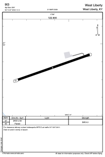
Runways:
| RWY identifier | QFU | Length (ft) | Width (ft) | Surface | LDA (ft) |
| 07 | 71° | 2400 | 60 | ASPH | |
| 25 | 251° | 2400 | 60 | ASPH |
Airport contact information
Address: West Liberty United States