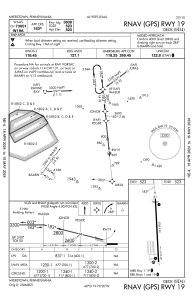
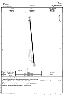


9D4 - Deck
Located in Myerstown, United States
ICAO - 9D4, IATA -
Data provided by AirmateGeneral information
Coordinates: N40°21'8" W76°19'47"
Elevation is 523 feet MSL.
Magnetic variation is -09° East View others Airports in Pennsylvania
Operational data
Special qualification required
Current time UTC:
Current local time:
Weather at : KMUI - Muir Aaf (Fort Indiantown Gap) ( 22 km )
METAR: KMUI 260155Z 04003KT 10SM SCT250 08/02 A3027 RMK AO2A SLP256 T00830017
TAF: TAF KMUI 251900Z 2519/2701 VRB06KT 9999 SCT030 BKN045 OVC060 620453 QNH3025INS BECMG 2614/2615 16006KT 9999 SCT035 BKN040 QNH3039INS TX15/2618Z TN07/2608Z
Communications frequencies: [VIEW]
Runways:
| RWY identifier | QFU | Length (ft) | Width (ft) | Surface | LDA (ft) |
| 01 | 354° | 3786 | 50 | ASPH | |
| 19 | 174° | 3786 | 50 | ASPH |
Airport contact information
Address: Myerstown United States
