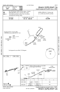
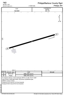


79D - Philippi/Barbour County Rgnl
Located in Philippi, United States
ICAO - 79D, IATA -
Data provided by AirmateGeneral information
Coordinates: N39°9'58" W80°3'44"
Elevation is 1755 feet MSL.
Magnetic variation is -09° East View others Airports in West Virginia
Operational data
Special qualification required
Current time UTC:
Current local time:
Weather at : KCKB - North Central West Virginia ( 20 km )
METAR: KCKB 150653Z 00000KT 9SM OVC070 16/14 A2974 RMK AO2 RAB03E41 SLP057 P0003 T01610144
TAF: KCKB 150520Z 1506/1606 00000KT P6SM BKN050 FM150730 00000KT P6SM VCSH BKN030 FM150900 00000KT P6SM OVC015 TEMPO 1510/1512 4SM -SHRA BR OVC007 FM151200 VRB03KT P6SM OVC015 FM151500 05006KT P6SM -SHRA BKN030 FM152200 06005KT P6SM -SHRA SCT030
Communications frequencies: [VIEW]
Runways:
| RWY identifier | QFU | Length (ft) | Width (ft) | Surface | LDA (ft) |
| 08 | 74° | 3275 | 60 | ASPH | |
| 26 | 254° | 3275 | 60 | ASPH |
Airport contact information
Address: Philippi United States