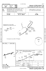
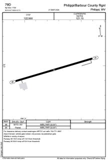


79D - Philippi/Barbour County Rgnl
Located in Philippi, United States
ICAO - 79D, IATA -
Data provided by AirmateGeneral information
Coordinates: N39°9'58" W80°3'44"
Elevation is 1755 feet MSL.
Magnetic variation is -09° East View others Airports in West Virginia
Operational data
Special qualification required
Current time UTC:
Current local time:
Weather at : KCKB - North Central West Virginia ( 20 km )
METAR: KCKB 291953Z VRB05KT 10SM CLR 28/14 A2999 RMK AO2 SLP143 T02830139
TAF: KCKB 291739Z 2918/3018 23006KT P6SM FEW060 FM292300 00000KT P6SM FEW250 FM301300 22006KT P6SM OVC200
Communications frequencies: [VIEW]
Runways:
| RWY identifier | QFU | Length (ft) | Width (ft) | Surface | LDA (ft) |
| 08 | 74° | 3275 | 60 | ASPH | |
| 26 | 254° | 3275 | 60 | ASPH |
Airport contact information
Address: Philippi United States