


69ND - Tengesdal
Located in Maxbass, United States
ICAO - 69ND, IATA -
Data provided by AirmateGeneral information
Coordinates: N48°44'36" W101°2'31"
Elevation is 1493 feet MSL.
Magnetic variation is 10° East View others Airports in North Dakota
Operational data
Special qualification required
Current time UTC:
Current local time:
Weather at : KMIB - Minot Afb ( 43 km )
METAR: KMIB 091255Z 32008KT 10SM FEW060 09/06 A3010 RMK AO2A SLP201 T00940061
TAF: TAF KMIB 090900Z 0909/1015 VRB06KT 9999 SCT065 QNH3007INS BECMG 0911/0912 35012G18KT 9999 SCT055 QNH3008INS BECMG 0921/0922 32010G15KT 9999 SCT050 OVC065 QNH3006INS BECMG 1002/1003 32010KT 9999 FEW050 QNH3009INS TX20/0921Z TN05/0912Z
Communications frequencies: [VIEW]
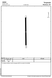
Runways:
| RWY identifier | QFU | Length (ft) | Width (ft) | Surface | LDA (ft) |
| 17 | 179° | 1500 | 40 | GRASS | |
| 35 | 359° | 1500 | 40 | GRASS |
Airport contact information
Address: Maxbass United States