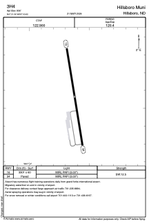


3H4 - Hillsboro Muni
Located in Hillsboro, United States
ICAO - 3H4, IATA -
Data provided by AirmateGeneral information
Coordinates: N47°21'34" W97°3'37"
Elevation is 906 feet MSL.
Magnetic variation is 05° East View others Airports in North Dakota
Operational data
Special qualification required
Current time UTC:
Current local time:
Weather at : KFAR - Hector Intl ( 52 km )
METAR: KFAR 081053Z 15004KT 10SM CLR 08/05 A2959 RMK AO2 SLP022 T00780050
TAF: KFAR 080520Z 0806/0906 15009KT P6SM SCT060 FM081500 09007KT P6SM SCT070 FM082200 04010KT P6SM VCSH BKN060 FM090200 02007KT P6SM SCT070
Communications frequencies: [VIEW]
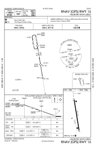
Runways:
| RWY identifier | QFU | Length (ft) | Width (ft) | Surface | LDA (ft) |
| 16 | 171° | 3301 | 60 | CONC | |
| 34 | 351° | 3301 | 60 | CONC |
Airport contact information
Address: Hillsboro United States